8:30 AM (Thurs, 2/6/25) – Late Wednesday night into very early Thursday morning, schools were delayed because of the icy conditions. As Thursday morning has progressed, more school districts across 21Country are either closing for the day or making today e-learning days. This includes all 4 big school districts in Allen County (FWCS, EACS, NACS, SACS). Check our website link below for the latest list of school/business delays and closures.
School/Business Closures and Delays
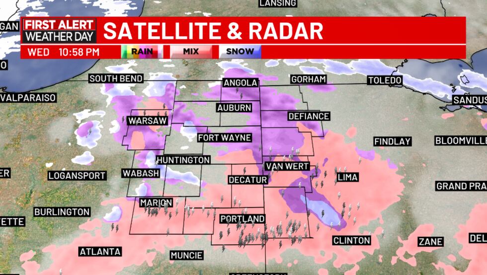
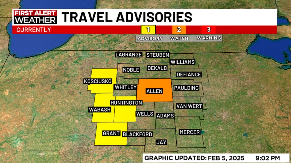
7:30 AM (Thurs, 2/6/25) – The First Alert Weather Day has ended as road conditions begin to improve, but several counties across 21Country are still under some level of travel advisory. Allen County is under a level two travel watch, while Grant, Huntington, Kosciusko, Wabash and Wells Counties in Indiana are under a level one travel advisory. Williams County Ohio is under a level two snow emergency.
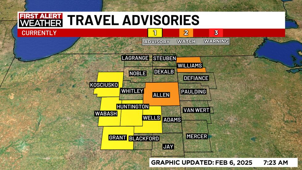
Thursday Morning Travel Advisories(WPTA)
As a reminder,
Travel Advisory (Level 1 Snow Emergency in Ohio) means drivers should exercise caution while driving.
Travel Watch (Level 2 Snow Emergency in Ohio) means essential travel only, like to and from work or in an emergency. Employees should contact their employers with regards to questions about reporting to work.
Travel Warning (Level 3 Snow Emergency in Ohio) means that travel may be restricted to emergency management workers only.
6:05 AM (Thurs, 2/6/25) – Several school districts are issuing 2-hour delays due to some icy roads, including all four major Allen County schools (NACS, SACS, EACS, and FWCS). You can see the full list of delays & closings here.
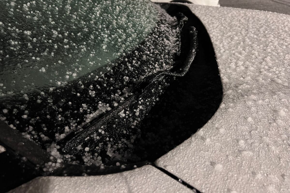
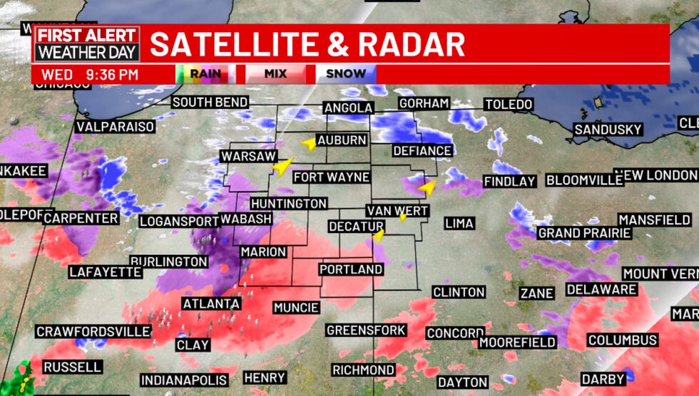
4:25 AM (Thurs, 2/6/25) – Freezing mist has become more widespread across 21Country. Visibility is limited to 1-2 miles across the entire area. Mist and drizzle is freezing on contact with all surfaces and keeping untreated surfaces slick.
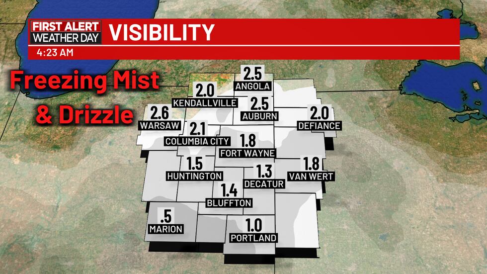
Freezing mist continues to be an issue early Thursday morning.(WPTA)
1:45 AM (Thurs, 2/6/25) – While radar may appear dry, we’re in fact not! Drizzle and mist (difficult to pick up on radar) linger in the area overnight, freezing on contact with surfaces. This is lowering visibility as low as a mile in some cases. Patches of freezing mist will continue throughout the morning, drying up across the region after sunrise.
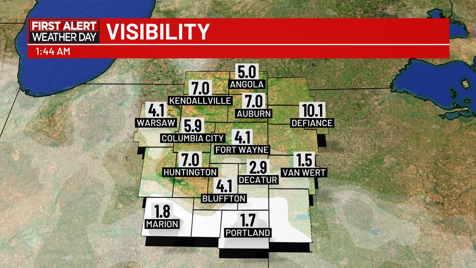
Mist and drizzle are freezing on surfaces overnight.(WPTA)
1:11 AM (Thurs, 2/6/25) – A combination of sleet and freezing rain continue to make surfaces icy. While the most widespread freezing rain and sleet has moved out, freezing mist will be patchy for the next few hours.


12:06 AM (Thurs, 2/6/25) – The steady freezing rain has subsided, though the concern now is freezing drizzle, which is a concern we have mentioned a few times this evening. In the radar snapshot below, you can see the difference between the freezing rain in Northwest Ohio (showing up in bright pink) and the freezing drizzle (in a bit of a hazier, lighter pink) over much of Northern Indiana.
Though there isn’t as much volume to contend with in this situation, drizzle can be dangerous in its own right as it will still freeze to surfaces it touches. Slick conditions are still expected for at least the next few hours.
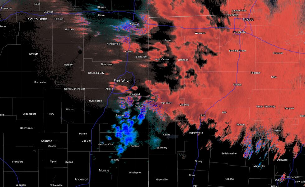
Radar snapshot showing freezing rain and drizzle(WPTA)
11:00 PM (Weds, 2/5/25) – I felt like we were going to need proof for those who missed it, so here’s a screenshot of the radar image as of 11pm – yup, that’s lightning, and it’s been thundering for about an hour now. Well, it’s been doing a lot of things: thundering, icing, raining. In fact, we came up with a new term for this bizarre phenomenon: Threezing Rain.
So how can this happen? If you have an airmass with conflicting temperature differences like the one over us right now (near 40 degrees 5,000 feet up in the air, but clinging to 30 at the surface), you’re bound to see some instability. What surprised me was how much we saw!
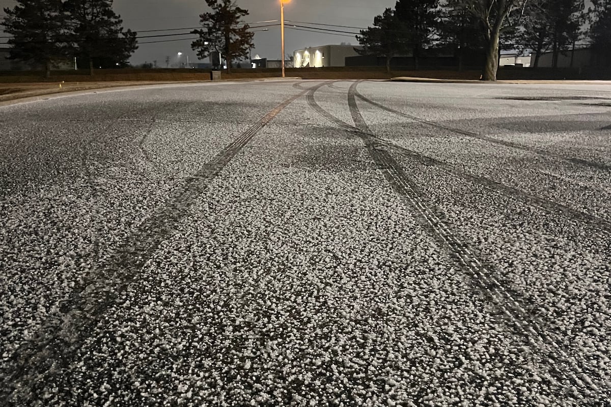
Roads are ice-covered in most places, though we haven’t seen any new additions to the advisory/watch list yet. The morning commute will start off icy for many, but conditions will improve as the morning progresses. How much improvement we see will depend greatly on how much ice manages to stick between now and then, and how quickly road crews can treat/keep up on the roads.
11p radar update (2/5/25)(WPTA)
10:14 PM (Weds, 2/5/25) – If you heard thunder, you’re not losing your mind – there’s quite a bit of lightning out there this evening! This is a very dynamic storm system, though this also means some of this rain, especially south of the Fort, is quite heavy which also means quick ice accumulation. Unlike the summer where you only have the thunderstorms themselves to worry about, tonight you have thunderstorms AND ICE to worry about! Best to stay indoors for the rest of the night!
9:40 PM (Weds, 2/5/25) – I’m watching a pocket of moderate freezing rain moving northeast into the area. This will very likely ice things up rapidly. This is particularly concerning for areas already experiencing iced-over roads. If you’re south and west of the Fort, expect conditions to become more treacherous over the next 15-30 minutes. In the Fort and areas north and east, within 45 minutes to an hour, though the heaviest precipitation still looks to be concentrated in our southern counties.
9:40 pm radar update(WPTA)
9:20 PM (Weds, 2/5/25) – A TRAVEL ADVISORY has been issued for Wells County due to slick conditions.
9:00 PM (Weds, 2/5/25) – A TRAVEL WATCH (Level 2/3) has been issued for Allen County due to slick and dangerous conditions. Only essential travel is recommended.
Travel advisories/watches as of 9:00 pm(WPTA)
8:52 PM (Weds, 2/5/25) – Most of you know by now how much I love thundersnow. The system moving through is so dynamic that we’re observing lightning amid the…freezing rain. What do we call this. Threezing rain? Freezing thunder? Certainly a strange combo! This batch of rain is moving north and east and will likely reach our neck of the woods in the next 30-45 minutes.
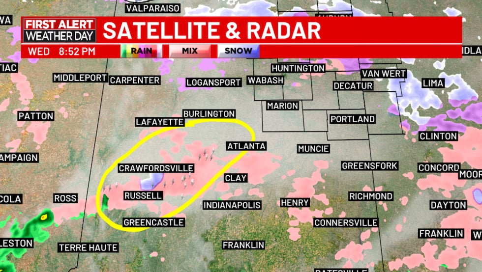
Observed lightning amid the freezing rain(WPTA)
8:35 PM (Weds, 2/5/25) – A TRAVEL ADVISORY has been declared for Huntington County due to slick conditions. As of now, here are the affected counties:
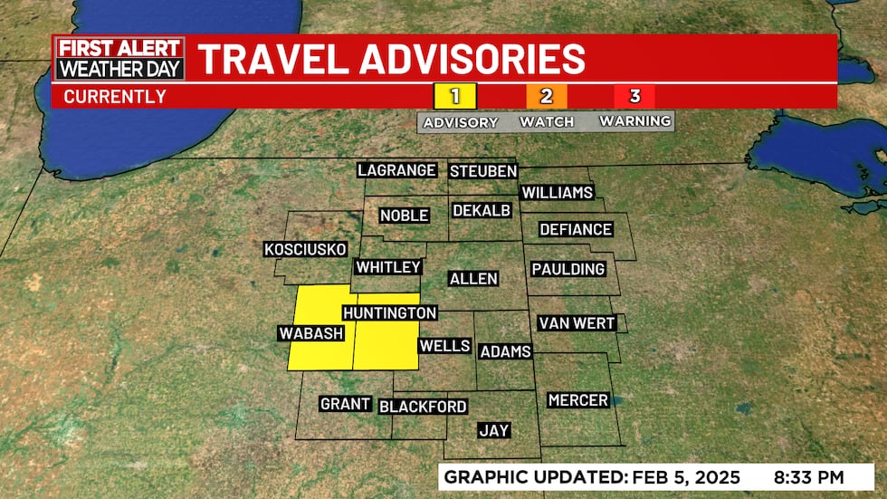
Travel Advisories as of 8:33 pm(WPTA)
Outside of pockets of freezing rain, there’s also plenty of freezing drizzle, which is something I think we’re going to have to deal with at times through the early morning hours tomorrow. This means even when there’s a break in the steady rain, ice build up could still occur.
Several comments on my Facebook page (Matt Leach 21Alive Weather) confirm travel is becoming increasingly treacherous in places like Wabash, Huntington, Fort Wayne, Kendallville, and Van Wert. I will post an updated radar image in moments!
8:06 PM (Weds, 2/5/25) – A TRAVEL ADVISORY has been declared for Wabash County due to slick conditions. Scattered freezing rain is currently streaming through Northern Indiana and Northwest Ohio with more precipitation expected to move in later this evening.
7:45 PM (Weds, 2/5/25) – While driving northbound on I-69 (around the Lima exit), I encountered a brief rain shower. Normally that wouldn’t have concerned me, but in this environment you should trust a rain shower about as much as you’d trust an e-mail from a prince who needs your help! Most areas around Fort Wayne and points south are experiencing these showers, though areas north (Auburn, Angola, Kendallville, etc) are not experiencing much yet. That will change in the coming hours.
Again—Assume anything falling out of the sky tonight will freeze on the road and sidewalk!
7:05 PM (Weds, 2/5/25) – Icy precip is falling in our southwestern communities as you can see on radar below. Radar is interpreting this as sleet (ice pellets), but I am seeing some signs of freezing rain not far behind. I believe the window for sleet is short, with all precipitation falling as freezing rain over the next hour or two.
More precipitation is streaming north and eastward from southern Illinois – it looks pretty scattered in nature at the moment, but I expect radar to fill in somewhat. I’m beginning to question how heavy/steady the freezing rain threat will be toward midnight at the moment based on how the radar looks.

Radar image 7:05p(WPTA)
6:10 PM (Weds, 2/5/25) – Seeing some scattered/light precipitation moving north and east into the 21Alive viewing area. Radar is identifying this as perhaps a bit of sleet/snow, but the expectation is the bulk of what falls tonight will be in the form of the more nefarious freezing rain.
The biggest ice threat is still expected to occur closer to 9 pm and continue into the overnight hours Thursday
5:30 PM (Weds, 2/5/25) – Radar image to our south shows a complex mix of precipitation across central Indiana and Illinois – sleet, freezing rain, and rain.

Radar image as of 5:30 pm Wednesday evening(WPTA)
The difference is all in temperatures at the surface vs. higher up in the atmosphere! A warmer weather system will promote warmer temperatures several thousand feet up, but that doesn’t always translate to warmer air at the surface. So, while what falls from the sky may be rain, once the raindrops hit a subfreezing surface, they supercool, thus resulting in a glaze of ice.
Sleet is more common when cold air in the upper levels of the atmosphere promote snowflakes, which, on their way down, melt into raindrops in a warm layer of the atmosphere, and then refreeze into ice pellets in a colder layer well above the surface before hitting the ground.
Fun, huh?!
We expect conditions to deteriorate on area roads between 7-10p tonight with the 11p-4 am time period likely being the most treacherous.

Different precipitation types is dependent on temperature at various levels of the atmosphere(WPTA)
5:10 pm (Weds, 2/5/25) – Keep checking this weather blog through early Thursday morning for frequent updates regarding road and weather conditions.
Copyright 2025 WPTA. All rights reserved.