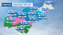
The final in our series of East Coast storms is headed our way this weekend. And it could be the one with the biggest impact.
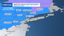
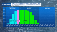
We’re tracking a mix of snow, ice, and rain that’ll make for a wintry Saturday and sloppy Sunday. Winter weather advisories are posted from Central Jersey up through the Hudson Valley. Check the latest weather alerts here.
If you need to run any errands this weekend, get them done early on Saturday. Saturday morning is the only time this weekend roads will be dry. By Saturday afternoon, things will be heading downhill.
With temperatures below freezing area-wide, it will be all snow when the precipitation starts around lunchtime. Temperatures will stay steady during the day and eventually rise by evening, initiating a changeover to mixed precipitation and eventually all rain in and around New York City.
South Jersey will be the first to transition to all rain, generally by early evening. The transition will happen in the city by mid to late-evening.
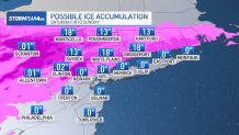
The Hudson Valley will see snow past midnight. Overnight, sleet and freezing rain will mix in.
Freezing rain falls as liquid rain and immediately freezes on contact with the sub-freezing surface it lands on. It creates a sheet of ice on roads, a hard, icy shell around the snow on the ground, and an icy layer on tree branches and power lines, weighing them down and causing them to snap if enough ice builds up.

Ice accumulations in the Hudson Valley could reach up to one to two tenths of an inch. Tree branches and power outages usually start to happen after a quarter inch of ice build-up.
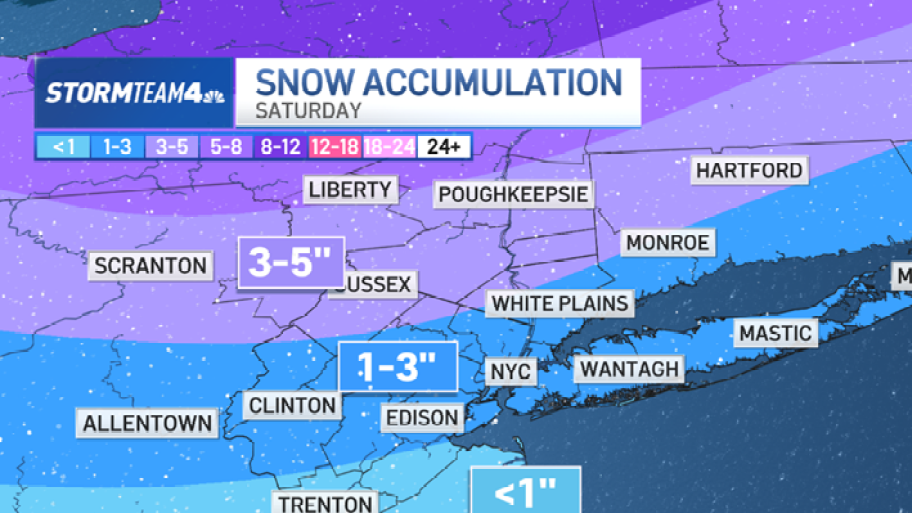
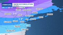
To the south, the milder temperatures and quick changeover to rain will result in diminutive snow totals down the Jersey Shore; expect less than an inch. In the city, on Long Island, and in northern New Jersey, most of us can look forward to an additional 1 to 3 inches of snow. Farther north, 3 to 5 inches are more likely.
On Sunday, rain will be the prevailing form of precipitation. It will turn much of the previous day’s snow into slush before making it disappear entirely. It’ll be a sloppy day, so wearing rain boots will be wise.
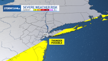
We could get a few pockets of heavy rain Sunday afternoon, just as the storm system begins to exit. And if you’re in South Jersey or on Long Island, you might even hear thunder.
By the evening, the rain will move out.
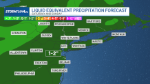
Totaling it all up, the rain, snow, and ice will account for about 1 to 2 inches of liquid equivalent precipitation, with about half an inch to an inch of that falling as rain.
Though the timing of this system puts a damper on most of the weekend, a good soaking is sorely needed.
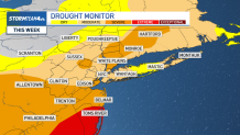
We are still running moderate to severe drought conditions across the region. On the downside, the soaking we get could come with isolated flooding of streets and low-lying areas.

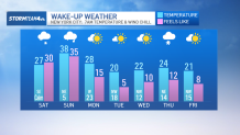
Once the storm is out, we’ll get to enjoy a couple rain-free, sunny days at the start of the week. Unfortunately, this sunshine is coming along with a precipitous drop in temperatures; we’ll have to endure several days with highs below the freezing mark and mornings that’ll feel like the teens and single digits. Parka weather is back in full force.