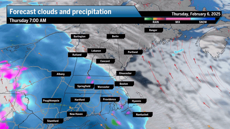
After a cold night with temperatures falling into the teens, clouds have arrived and snow is moving steadily toward the coastline. Depending on when and where you read this the snow may have begun, but it should reach the Boston area between about 9 and 10 a.m.
The cold air is an important part of the storm today. As the warmer air hits this cold dome of air this morning, it will be forced up, creating what we call “lift” from a process known as “overrunning.” This lift leads to clouds and precipitation. Initially, it is cold enough from the clouds down to the ground for snow to fall. But eventually a warmer layer of air between where the snowflakes are forming and here at the ground will end up creating sleet and freezing rain.
I don’t think the temperatures are going to rise above freezing from roughly west of Boston and north of the city. Those of you on Cape Cod and the islands will go above freezing and that’s where the least amount of snow will fall and where precipitation is likely to mix with and eventually change to rain before ending.
If you want to avoid the snow, then head out early this morning and stay at work until after 5 p.m. It’s between this time that most of the precipitation will fall. Most of the snow will accumulate in a small three- to four-hour window from about 9 a.m. until noon or 1 p.m. Here’s the latest breakdown:
• 7 a.m. to 9 a.m. – West of Worcester snow may arrive before 8 a.m. Rhode Island will start seeing snow in this window.
• 9 a.m. to 10 a.m. – Snow starts in Boston after school bus runs and most workers to get to their destination.
• 10 a.m. to 1 p.m. – There will be a burst of snow between roughly 10 a.m. and 1 p.m. and and this is when most of the accumulation will occur — 1 to 3 inches of snow for the Boston area, northern Rhode Island, New Hampshire and the rest of Northern New England. The snow could be briefly moderate or heavy. There could be a few spots that see slightly higher totals, maybe closer to 4 inches, especially north of the Mass Pike. Higher elevations could see up to 6 inches of snow.
• 1 p.m. to 3 p.m. – In the afternoon, the precipitation will do two things: The snow will become lighter and it will transition over to a mixture of sleet and freezing rain.
This isn’t going to be a lot of precipitation and treated roads and highways should be fine in the afternoon. However, untreated roads and walkways — and even your car — could accumulate a light coating of glaze in the afternoon before the precipitation comes to an end in the evening. Be sure you have the ice scraper handy to clean the car windows.
• 3 p.m. to 5 p.m. – The end time for this mixed bag of precipitation is likely between 3 and 5 p.m., at which point temperatures may fall back a couple of degrees to just under 30 overnight.
This is relatively mild and any melting products on roadways and walkways will work very well. This doesn’t mean there won’t be slick spots. This is just not going to be a widespread icing event.
There’s a break in the action on Friday when temperatures approach 40 degrees in the afternoon, so lots of melting. Saturday is also dry with temperatures in the 30s.
Our next storm arrives Saturday night and Sunday looks like more snow perhaps changing to rain south of Boston, but 6 inches or more of snow is possible for those areas that stay all snow. Saturday night and Sunday and it looks like more snow perhaps changing to rain. I’ll have more details on that storm in the coming days.
Southern New England: Snow changes to a mixed bag of precipitation after many areas receive 1to 3 inches of snow and sleet. There will be some glaze on top of the snow this afternoon. Temperatures will be around freezing in the afternoon.
Western Mass.: Look for 1 to 3 inches of snow during the day today, coming to an end later this morning. Clouds will linger through the afternoon with some spotty freezing drizzle. Temperatures will be in the upper 20s.
Cape and islands: Look for any snow quickly changing to a mixed bag of precipitation and even rain with a coating to an inch of snow before the changeover. Temperatures will reach into the 30s.
Northern New England: Snow overspreads the area during the morning with 2 to 4 inches of snow in most places. A few areas will see 3to 6 inches.
Sign up here for our daily Globe Weather Forecast that will arrive straight into your inbox bright and early each weekday morning.