The pattern has gone haywire. Admittedly, the next 10 days may give you flashbacks to the infamous snow blitz 10 years ago, but at least in this case, we may be skipping out on the blockbuster snowstorms.
We’ve issued a First Alert for Thursday, the first of a series of winter storms moving into our area in the coming days.

How many chances for snow do we have in the next week?
Still, FOUR (potentially five) storms in the next seven to 10 days is a lot. While the temperatures won’t be numbingly cold, it will be just cold enough to snow for most of us.
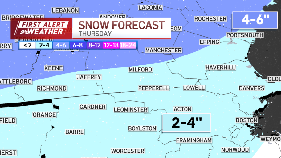
Today seems to be the exception. While we see a burst of snow through late morning, the upper atmosphere is warming up, signaling a changeover by noontime. This will keep snow accumulations on the order of 2-4 inches for most, with 2 or less on the South Shore and spotty light accumulations on Cape Cod. Highs will stay in the low 30s, with only towns and cities near the coast busting into the upper 30s. The event will wrap by late afternoon and early evening.
Thursday snowfall estimates

Still, dozens of school districts have canceled classes for the day due to the weather. See the full list here.
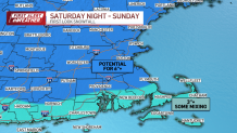
Sunday storm could dump more than 6 inches of snow
We’ll get a break for a couple of days, then watch a bigger storm move in by midnight Saturday night.

This one has all the markings of a solid New England snowstorm. While we may see some mix through Buzzards Bay and the Cape/Islands, this is predominantly a snowmaker for us. Strong lift in the upper atmosphere, cold temperatures to fluff up the snow, a developing coastal front – all point to at LEAST 6” of snow areawide, with the potential for nearly a foot in isolated spots.
As if that wasn’t enough, there are two (possibly three) more storms next week! It’s gotten so crowded, the models are having a difficult time with timing and intensity. While I don’t see any blockbusters (well over a foot), there is potential for 6” or more in some of these storms with the “right” track.
We’ll stay on top of all of them. Join us as we watch the snowbanks grow: online, on-air, on our social media pages or wherever you stream.