NWS confirms preliminary EF-1 tornado hit Hart County, Kentucky
 Updated: 5:14 PM EST Feb 6, 2025
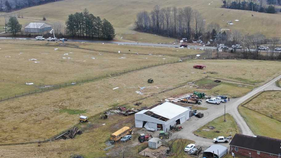
AIRPORT’S OPERATIONS COMMAND CENTER. STORMS ROLLED THROUGH THE AREA EARLY THIS MORNING, AND TODAY WE LEARNED A TORNADO DID TOUCH DOWN SOUTH OF LOUISVILLE. THE NATIONAL WEATHER SERVICE CONFIRMS A PRELIMINARY EF ONE TORNADO IN HART COUNTY, WHICH BORDERS LARUE, HARDIN, GREEN AND GRAYSON COUNTIES. WLKY NEWS CHOPPER FLEW OVER THE NORTHEAST AREA OF THE COUNTY, AND YOU CAN SEE SOME DAMAGE TO SOME OF THE BARNS AND ROOFS. DOWNED TREES AND A LARGE DEBRIS FIELD SPREAD ACROSS FIELDS. WIND SPEEDS GOT UP TO 95MPH, AND SO FAR NO INJURIES HAVE BEEN REPORTED, AND THE MORNING STORMS ALSO CAUSED SOME DAMAGE AND DOWNED POWER LINES IN HARDIN COUNTY. OUR SHAQUILLE LORD WAS THERE THIS MORNING WHERE OFFICIALS SAY THEY ARE BREATHING A SIGH OF RELIEF. THE DAMAGE WASN’T WORSE. WHEN SPEAKING TO THE HARDIN COUNTY EMERGENCY MANAGEMENT DIRECTOR, HE SAYS IN COMPARISON TO THE PAST FEW FEBRUARY’S, WHEN IT COMES TO DEALING WITH STORMS AROUND THIS TIME OF THE YEAR. HARDIN COUNTY MADE IT OUT EXTREMELY LUCKY. YOU KNOW, WE HAD SOME REPORTS OF SOME DOWNED POWER LINES, SOME DOWNED TREES IN THE AREA. LIGHTNING HIT A HOUSE, BUT OTHER THAN THAT, I THINK WE FARED PRETTY WELL DUE TO THE DUE TO THE TEMPERATURE CHANGE AND GOING FROM 40 DEGREES TO 70 DEGREES OVERNIGHT. WAS A IT COULD HAVE DEFINITELY BEEN BAD. AND K-U CREWS DID A GREAT JOB WHEN IT CAME TO RESPONDING AND FIXING THE ELECTRICITY IN THE AREA.
NWS confirms preliminary EF-1 tornado hit Hart County, Kentucky
Updated: 5:14 PM EST Feb 6, 2025
The National Weather Service is surveying areas just south of Louisville after storms rolled through early Thursday.According to the NWS, there was a preliminary EF-1 tornado just outside of the WLKY viewing area in Hart County, which borders LaRue, Hardin, Green and Grayson counties.(Scroll down for more aerials of the damage)Wind speeds got up to 95 mph.So far, no injuries have been reported.The rest of the day will be relatively quiet, with possibly some showers again into the night south of Louisville.There will be more chances for impact weather Saturday and into next week.
LOUISVILLE, Ky. —The National Weather Service is surveying areas just south of Louisville after storms rolled through early Thursday.
According to the NWS, there was a preliminary EF-1 tornado just outside of the WLKY viewing area in Hart County, which borders LaRue, Hardin, Green and Grayson counties.

(Scroll down for more aerials of the damage)
Wind speeds got up to 95 mph.
So far, no injuries have been reported.
The rest of the day will be relatively quiet, with possibly some showers again into the night south of Louisville.
There will be more chances for impact weather Saturday and into next week.