TALLAHASSEE, Fla. (WCTV) – [1/22 1 a.m.] Mike has the latest on snowy conditions as a rare winter storm moves through our area.
Various types of winter precipitation will continue to fall throughout the overnight hours.
[1/21 9 p.m.] We are beginning to see road closures and numerous car crashes as wintry conditions continue to blanket the Big Bend. For a full list of crashes and closures, click here.
[1/21 6:45 p.m.] Various types of winter precipitation will continue to fall throughout the overnight hours. A few inches of snow has already been recorded across portions of Southwest Georgia.
Reference the below graphic to see which kind of precipitation you should expect the most of. A ‘wintry mix’ is a combination of snow, sleet, and freezing rain.

Where is each type of precipitation the most likely.(wctv)
The last time we had measurable snowfall in Florida’s capital city was 2018, with only a tenth of an inch recorded. We will be getting a bit more than that this time around.
The all-time record snowfall for Tallahassee is 2.8 inches and was set back in December of 1989. The amount of sleet we are getting so far is eating up the snow, so perhaps we won’t break that record this time around. Time will tell! Stay tuned!
[1/21 5:45 p.m.] The snow is coming down fast now!
Sports anchor Alison Posey saw snow for the first time Tuesday in Tallahassee!
[1/21 5:30 p.m.] It’s here! Snow is falling in Tallahassee.
[1/21 4:45 p.m.] Sleet has started falling in Tallahassee as a winter storm closes in on the Big Bend and South Georiga.
Our Josh Green stepped outside the WCTV studios to check out the winter precipitation and explain how it forms. See him break down what sleet is in the video below.
Our Josh Green stepped outside the WCTV studios to check out the winter precipitation and explain how it forms. See him break down what sleet is in this video.
[1/21 2 p.m.] Mixed precipitation (including snow) is moving into the Florida panhandle and Southwest Georgia as of 2:00pm Tuesday.
See the attached images below for our forecast snowfall totals, ice accumulation, and most likely type of precipitation across the Big Bend & South Georgia. A wintry mix includes snow, sleet, and freezing rain.

Where is each type of precipitation the most likely.(wctv)

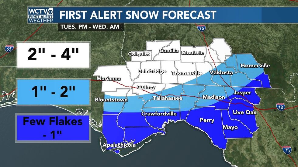
First Alert Snow Forecast(wctv)

First Alert Ice Accumulation Forecast(wctv)
Watch Rob’s attached forecast for the latest information.
[1/20 6:15pm] As new model data comes in Monday evening, the WCTV First Alert Weather team has increased the snowfall forecast for portions of our region.
Let’s start with timing. For our western counties (near the Apalachicola River), moisture is looking to return between 3 p.m. and 5 p.m.
It will continue marching east through the evening. For the central portions of our region (near Tallahassee and Thomasville), we are anticipating a start time between 4 p.m. and 7 p.m.
For our eastern counties (near I-75), moisture will arrive Tuesday night. The current thinking is 6 p.m. – 8 p.m.
SNOW FORECAST:
In terms of the snowfall forecast, here are the changes:
From Marianna to Bainbridge to Moultrie and back to the northwest (white), we are anticipating 1.5″-3″ of snow.
From generally the I-10 corridor and points north (light blue), we are tracking the potential for 0.5″-1.5″. Notice, the forecast is lower near the I-10 corridor in our eastern counties because the atmosphere looks to be more conducive for mixing.
For the Suwannee River valley and coastal areas (dark blue), we are anticipating between a few flurries and 0.5″.
(keep reading below for ice forecast)
Updated Snow Forecast(WCTV)
ICE FORECAST:
The ice forecast is relatively unchanged. The higher chance for ice accumulation looks to stay near the I-75 corridor and the Suwannee River valley (purple). Here, we could see between 0.10″ and 0.25″of ice.
For the areas in pink, we are anticipating between a glaze of ice and 0.10″. It may not sound like much, but it does not take much ice to cause power outages and cause dangerous travel, so be sure to take that seriously.
Further north (areas in white), we are anticipating mostly snow with this winter storm.
(keep reading… almost done)
Ice Forecast(WCTV)
More tweaks and updates are possible with the forecast over the next 12 hours or so as more model data comes in, so be sure to stay weather aware and keep up with the forecast.
Travel could be dangerous for the first part of Wednesday. Temperatures dip into the mid-and-upper-20s by Wednesday morning, and we should stay below freezing until after lunchtime, so it may take some time for melting to occur.
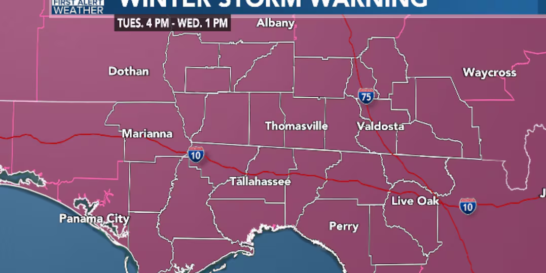
[1/20 2:30 pm] The National Weather Service has issued a Winter Storm Warning for the Big Bend and South Georgia as the region prepares for potential winter impacts.
The warning will last from 4 p.m. Tuesday to 1 p.m. Wednesday.
The National Weather Service has issued a Winter Storm Warning for the Big Bend and South Georgia as the region prepares for potential winter impacts.(WCTV)
[1/20 11:45am] The forecast is relatively unchanged for Tuesday. We are still anticipating winter weather across the Big Bend and South Georgia. A Winter Storm Watch is in place for the entire region.
In terms of timing, moisture looks to increase in our western counties around 4 p.m., and it will continue spreading east. Moisture begins to exit the eastern part of the region by sunrise on Wednesday.
All modes of wintry precipitation are possible (rain, snow, sleet and freezing rain). The better chance to see all snow will stay in our northwestern counties (Jackson, Seminole, Miller and Decatur). Here, we are anticipating an inch with locally higher amounts.
For areas generally along and north of the I-10 corridor (light blue), we are anticipating between 0.5″ and 1″.
Notice near the I-10 corridor in our eastern counties, the forecast is lower because we are tracking an increased ice threat here. For the Suwannee River valley and coastal areas (dark blue), we could range from a few flurries to up to 0.5″.
(story continues below)
Snow Forecast(WCTV)
In terms of the ice potential, the higher chance to see impactful ice (0.10″ – 0.25″) will stay from Tallahassee to Crawfordville and back to the east near the I-75 corridor (purple).
Elsewhere, we could see anywhere from a glaze of ice to up to a 0.10″ (pink).
Ice Forecast(WCTV)
Impacts to travel and power are possible with this system. It is important to stay off the roads Tuesday evening and Tuesday night.
[1/19 9:15pm] As confidence continues to increase in winter weather across our region Tuesday evening, the WCTV First Alert Weather team has issued the first snow and ice forecast for the event.
It is important to remember, the forecast will likely change over the next 24-36 hours, so be sure to keep up with the forecast through Tuesday morning.
In terms of snow, the better chance for mainly snow will be in our far northwestern counties (northern Jackson, northern Seminole and Miller counties). Here, we are anticipating roughly an inch with locally higher amounts.
For areas generally along and north of the I-10 corridor (light blue), we are anticipating 0.5″ to 1″ of snow.
For places south of I-10 and in the Suwannee River valley (dark blue), mixed precipitation should keep snow totals lower. Here, we are anticipating between a few flurries and up to 0.5″.
(keep reading below for ice forecast)
Snow Forecast(WCTV)
In terms of ice, at this point, the greater chance for accumulating ice is looking to be near the Suwannee River valley (purple). Here, we could see ice between 0.10″ and 0.25″.
For the rest of us (pink color), ice could still be an issue. We are anticipating between a glaze and 0.10″.
Ice Forecast(WCTV)
Again, changes to the forecast are possible over the next 24-36 hours, so keep up with the latest.
[1/19 3pm] The National Weather Service has issued a Winter Storm Watch for the Big Bend and South Georgia as the region prepares for potential winter impacts.
The watch will be in effect from Tuesday evening through Wednesday early afternoon.
You can watch the 1 p.m. update with Mike and Josh below:
Stay tuned with WCTV for more updates.
Winter Storm Watch(WCTV)
[1/19 11:00am] We are preparing for a rare and significant winter weather event across the Big Bend and South Georgia. Let’s discuss the details.
Here’s a timeline of events
- Monday will be cold, mostly sunny, and dry with morning lows in the 20s and afternoon highs in the 40s.
- Tuesday morning will be cold with temperatures near 30. The first half of the day on Tuesday will be mainly cloudy and dry.
- Precipitation will arrive from the west around Tuesday afternoon & evening. All types of precipitation are possible (rain, freezing rain, sleet, and snow).
- A wintry mix of precipitation will continue through Tuesday night.
- The wintry mix of precipitation will move out of our area on Wednesday morning.
Now here are the details
- A wintry mix is likely across the Big Bend and South Georgia. A wintry mix is a combination of freezing rain, sleet, and snow. Regular old rain is likely to mix in at some point as well, especially on Tuesday afternoon/evening and especially in the Big Bend of Florida.
- Freezing rain causes issues to roadways, trees, and powerlines.
- The further north you go, the higher the chances for more snow and less of a wintry mix. For example, spots around Albany GA are more likely to get only snow rather than a wintry mix. The southeastern Big Bend is more likely to receive rain and a wintry mix rather than only snow. It’s a headache of precipitation for all spots in between.
Here are the details that are being fine-tuned as of Sunday
- Getting specific on a local level when it comes to who will see what kind of precipitation.
- Snow totals and ice accumulation totals.
What you can do today
- Continue to check in with our weather team on-air and online.
- Keep an eye & ear out for any information from your local officials.
- Make a plan to stay off the roadways Tuesday evening through Wednesday morning if possible.
To stay updated on all the latest forecasts and weather, follow WCTV First Alert Weather on Facebook and X (Twitter).
Click here to see all the latest weather headlines and here to view the First Alert Radar. Receive push alerts and watch the latest forecast anytime on the free WCTV First Alert Weather app. Click hereto download it now.
Interested in becoming a WCTV First Alert Weather Watcher? Click here to join the team!
Copyright 2025 WCTV. All rights reserved.
